Remote Sensing Sdk
Advertisement
Geomatica FreeView v.9. 1. 2005
Geomatica FreeView is a flexible data viewing tool supporting over 100 raster and vector formats for loading, viewing, selection, and enhancement. FreeView is useful for any geospatial data viewing application, and is freely distributable.
Advertisement
ERDAS ECW JPEG 2000 Plug-in for v.11.0.1.250
Digital imagery is becoming more and more ubiquitous as time goes by.
Encom PA Viewer v.11.0
Encom PA provides advanced interactive visualisation in one-, two-, and three-dimensions with support for most geophysical and geological information types used by companies to cover regional exploration through to mine development.
Metria CityModeler v.6 6
Metria CityModeler creates 3D city models from pairs of Very High Resolution satellite scenes. The scenes may be from different times and even different satellites.
LayerTransparency v.1.0
When working with ArcMap, it is inevitable that you will want to look through layers and see how they overlay on top of the layers underneath.
ADLCONF v.3. 2. 2135
ADLCONF is a suite of software utilities for configuring and troubleshooting the Pacific Crest Advanced Data Link (ADL) line of digital communication radios and modems.
Cimel Update v.1 8
CIMEL Electronique offers a free update system, simple and effective for the software updates. To always use the latest CIMEL software, run regularly CIMEL Update.
Trimble PDLCONF v.4.0.0.24
Instructions for upgrading PDL firmware (also available on page 14 of the PDLCONF User Guide): - Download the PDL/EDL operating firmware into the directory where PDLCONF/EDLCONF is located.
MCC-LIDAR v.1.0
MCC-LIDAR is a C application for processing LiDAR data in forested environments. It classifies data points as ground or non-ground using the Multiscale Curvature Classification algorithm.
ILWIS Open v.3.6.0.1
ILWIS Open integrates image, vector and thematic data in one unique and strong desktop package. It delivers a wide range of feautures including import/export, digitizing, editing, analysis and display of data,
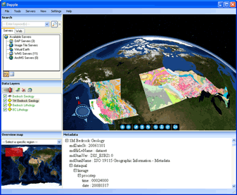
Dapple v.2.1.4
Dapple is a global data explorer designed to provide an open and optimal environment for visualizing, presenting and sharing massive quantities of geoscientific data on desktop computers.